• SynergyNDS
  • Home
  • About Us
  • Our Services
  • Managed Programs
  • Projects
    • Current Projects
    • Past Projects
    • Bids
  • Testimonials
  • Videos
  • Contact Us
  • FMIT Alerts

Call us today! 888.580.7080

Our Location
simpliCity Login
SynergyFMITSynergyFMIT
SynergyNDS is a leading Recovery Program
Manager for Public Entities with combined current
insured property in excess of $68 billion dollars.
synergynds, synergy recovery of florida, florida league of citiesSynergyNDS, Synergy Recovery of Florida, Florida League of CitiesSynergyNDS, Synergy Recovery of Florida, Florida League of CitiesSynergyNDS, Synergy Recovery of Florida, Florida League of CitiesSynergy Recovery of Florida, SynergyNDS, Florida League of Cities
  • SynergyNDS
  • Home
  • About Us
  • Our Services
  • Managed Programs
  • Projects
    • Current Projects
    • Past Projects
    • Bids
  • Testimonials
  • Videos
  • Contact Us
  • FMIT Alerts

Matthew Strengthens Into CAT 1 Hurricane With Winds Around Center Increasing to 75mph As It Moves Into The Caribbean

FMIT Alert Level 1:
Low
Matthew Strengthens Into CAT 1 Hurricane With Winds Around Center Increasing to 75mph As It Moves Into The Caribbean. Potential Florida Impact Next Week Remains Uncertain.
3:00pm EST, Thursday, September 29, 2016

Latest from the National Hurricane Center:

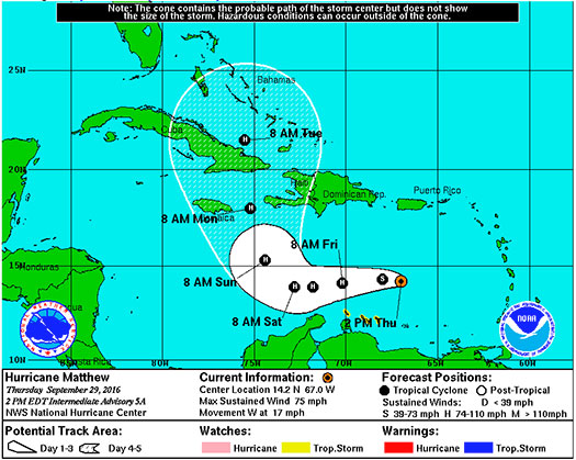
“At 200 PM AST (1800 UTC), the center of Hurricane Matthew was located near latitude 14.2 North, longitude 67.0 West. Matthew is moving toward the west near 17 mph (28 km/h), and a general westward motion with some decrease in forward speed is expected during the next couple of days.”

Latest From FMIT:
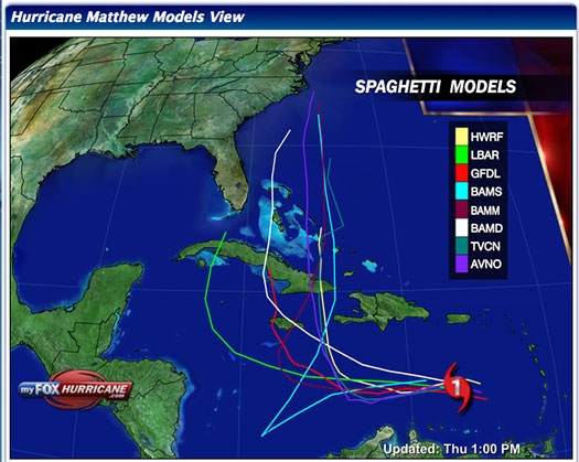
FMIT continues to monitor Hurricane Matthew. Forecast models generally predict that it will continue to head West for the next 3 days and then beginning to turn towards the North. Current path models predict that it will narrowly pass Florida to the East sometime later next week. We will continue to send updates as the Hurricane progresses.
Storm Imagery (Courtesy www.nhc.noaa.gov/ and www.myfoxhurricane.com/ )
Additional information and imagery can be found on your simpliCity℠ Dashboard.

FMIT Discussion

  • Tropical Storm Matthew strengthened into a CAT 1 Hurricane this afternoon with winds now up to 75mph.
  • West forward movement speed at 17mph with projections to begin turning North over the weekend.
  • Current path models predict that it will narrowly pass Florida to the East sometime later next week.

FMIT Member Preparedness Actions

  • Members should continue to monitor the storm as well as FMIT Alerts and local/national weather forecasts.
Share

You also might be interested in

Tropical Storm CindyTropical Storm Cindy Makes Landfall Early This Morning on Texas/Louisiana Border.

Jul 7, 2017

FMIT Alert Level 3 Moderate Tropical Storm Cindy Makes Landfall[...]

99L Forms into Tropical Depression 9 Over The Weekend. TD9 Remains Relatively Weak & Unorganized as it Moves West Into The Gulf of Mexico. Most Forecast Models Predict Potential Landfall As Tropical Storm Later This Week in FL.

Aug 29, 2016

FMIT Alert Level 2: Low-Moderate 99L Forms into Tropical Depression[...]

As Irma Leaves The Southern Gulf Coast, CIRT Rideout Teams Deployed To Affected Areas To Begin Completing Damage Assessments Once Conditions Become Safe. 9-10-17

Sep 11, 2017

FMIT Alert Level 5 High As Irma Leaves The Southern[...]

Contact Information
  • SynergyNDS
  • 1400 Sarno Rd Melbourne, FL 32935
  • 888.580.7080

TrackDown℠ Mobile Application


Get it on Google Play


Download on the App Store
Links

Florida League of Cities
simpliCity
Florida Municipal Insurance Trust
Synergy ID

Click For More Information
simpliCity
Managed Vendor Program

© 2025 — SynergyNDS

  • Home
  • About Us
  • Our Services
  • Managed Programs
  • Projects
  • Testimonials
  • Videos
  • Contact Us
  • FMIT Alerts
Prev Next