



• SynergyNDS
  • Home
  • About Us
  • Our Services
  • Managed Programs
  • Projects
    • Current Projects
    • Past Projects
    • Bids
  • Testimonials
  • Videos
  • Contact Us
  • FMIT Alerts

Call us today! 888.580.7080

Our Location
simpliCity Login
SynergyFMITSynergyFMIT
SynergyNDS is a leading Recovery Program
Manager for Public Entities with combined current
insured property in excess of $68 billion dollars.
synergynds, synergy recovery of florida, florida league of citiesSynergyNDS, Synergy Recovery of Florida, Florida League of CitiesSynergyNDS, Synergy Recovery of Florida, Florida League of CitiesSynergyNDS, Synergy Recovery of Florida, Florida League of CitiesSynergy Recovery of Florida, SynergyNDS, Florida League of Cities
  • SynergyNDS
  • Home
  • About Us
  • Our Services
  • Managed Programs
  • Projects
    • Current Projects
    • Past Projects
    • Bids
  • Testimonials
  • Videos
  • Contact Us
  • FMIT Alerts

Tropical Storm Matthew Forms Near Windward Islands Producing Heavy Rain & Strong Winds in Parts of the Lesser Antilles

FMIT Alert Level 1:
Low
Tropical Storm Matthew Forms Near Windward Islands Producing Heavy Rain & Strong Winds in Parts of the Lesser Antilles. Possibility of Hurricane Formation By This Weekend As it Moves Into The Caribbean. Potential Florida Impact Next Week Currently Uncertain.
4:00pm EST, Wednesday, September 28, 2016

Latest from the National Hurricane Center:

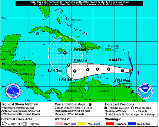
“At 200 PM AST (1800 UTC), the center of Tropical Storm Matthew was located near latitude 13.6 North, longitude 61.3 West. Matthew is moving toward the west near 20 mph (31 km/h). A westward motion with some decrease in forward speed is expected during the next couple of days. On the forecast track, the center of Matthew will move away from the Windward Islands through this evening, and be over the eastern and central Caribbean Sea through Friday.”

Latest From FMIT:
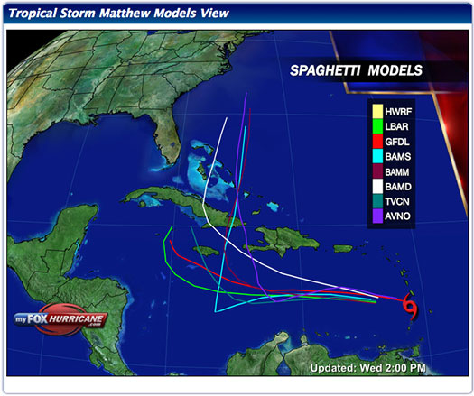
FMIT is currently monitoring Tropical Storm Matthew. The Storm is projected to intensify quickly over the next 48 hours into a hurricane. Forecast models generally predict that it will continue to head West for the next 3 days and then beginning to turn towards the North. Current path models predict that it will narrowly pass Florida to the East sometime later next week. We will continue to send updates as the Storm progresses.
Storm Imagery (Courtesy www.nhc.noaa.gov/ and www.myfoxhurricane.com/ )
Additional information and imagery can be found on your simpliCity℠ Dashboard.
FMIT Discussion

  • Tropical Storm Matthew has formed near the Windward Islands as of this afternoon with winds currently at 60mph.
  • High chance of hurricane formation as early as Friday as it moves into The Caribbean.
  • West forward movement speed at 20mph.
  • Current path models predict that it will narrowly pass Florida to the East sometime later next week.

FMIT Member Preparedness Actions

  • Members should continue to monitor the storm as well as FMIT Alerts and local/national weather forecasts.
Share

You also might be interested in

FMIT Alert Lvl 1 -Invest 94L Located over the Bahamas Projected to Bring Rain to FL This Week-Currently Low Chance of Cyclone Development 7-22-19

Jul 22, 2019

To Sign Up For FMIT Alerts CLICK HERE To Sign[...]

FMIT Alert Level 1: Hurricane Irma Weakens Slightly Over The Last 24 Hours With Maximum Sustained Winds Now at 110mph. 9-1-17

Sep 1, 2017

FMIT Alert Level 1 Low Hurricane Irma Weakens Slightly Over[...]

TD9 Strengthens Into Tropical Storm Hermine as it Continues On Path Towards Florida. NHC Tropical Storm Warnings and Limited Hurricane Watches For Areas of Northern Florida From Panama City to Tampa Remain in Effect

Aug 31, 2016

FMIT Alert Level 3: Moderate TD9 Strengthens Into Tropical Storm[...]

Contact Information
  • SynergyNDS
  • 1400 Sarno Rd Melbourne, FL 32935
  • 888.580.7080

TrackDown℠ Mobile Application


Get it on Google Play


Download on the App Store
Links

Florida League of Cities
simpliCity
Florida Municipal Insurance Trust
Synergy ID

Click For More Information
simpliCity
Managed Vendor Program

© 2026 — SynergyNDS

  • Home
  • About Us
  • Our Services
  • Managed Programs
  • Projects
  • Testimonials
  • Videos
  • Contact Us
  • FMIT Alerts
Prev Next