• SynergyNDS
  • Home
  • About Us
  • Our Services
  • Managed Programs
  • Projects
    • Current Projects
    • Past Projects
    • Bids
  • Testimonials
  • Videos
  • Contact Us
  • FMIT Alerts

Call us today! 888.580.7080

Our Location
simpliCity Login
SynergyFMITSynergyFMIT
SynergyNDS is a leading Recovery Program
Manager for Public Entities with combined current
insured property in excess of $68 billion dollars.
synergynds, synergy recovery of florida, florida league of citiesSynergyNDS, Synergy Recovery of Florida, Florida League of CitiesSynergyNDS, Synergy Recovery of Florida, Florida League of CitiesSynergyNDS, Synergy Recovery of Florida, Florida League of CitiesSynergy Recovery of Florida, SynergyNDS, Florida League of Cities
  • SynergyNDS
  • Home
  • About Us
  • Our Services
  • Managed Programs
  • Projects
    • Current Projects
    • Past Projects
    • Bids
  • Testimonials
  • Videos
  • Contact Us
  • FMIT Alerts

TD9 Shows Little Signs of Significant Growth or Increase in Organization Since This Morning as it Continues to Move West Into The Gulf of Mexico. Majority of Forecast Models Still Predicting Potential Landfall As Tropical Storm Later This Week in FL.

FMIT Alert Level 2:
Low-Moderate
TD9 Shows Little Signs of Significant Growth or Increase in Organization Since This Morning as it Continues to Move West Into The Gulf of Mexico. Majority of Forecast Models Still Predicting Potential Landfall As Tropical Storm Later This Week in FL.
3:00 pm EST, Monday, August 29, 2016

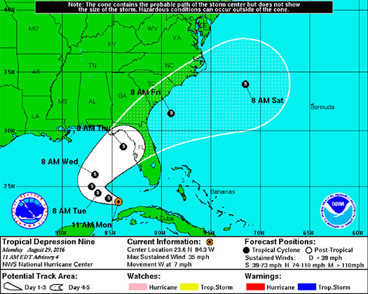
Latest from the National Hurricane Center:

“The depression is moving toward the west near 7 mph (11 km/h). A turn toward the west-northwest is forecast today, followed by a slow northwestward motion on Tuesday. A turn toward the north is expected Tuesday night. On the forecast track, the center of the depression will be passing north of the north coast of western Cubatoday, and moving farther into the southeastern Gulf of Mexico tonight and Tuesday.”

FMIT Ride-Out teams will remain on standby throughout the the week as the path and strength of the tropical depression become more clear. Future alerts will be sent twice daily due to the storm’s projected path into FL later this week. Should the storm develop significantly, we will arrange pre-event webinars and calls to educate Members on FMIT’s mitigation and response procedures.
Storm Imagery (Courtesy www.nhc.noaa.gov/ and www.myfoxhurricane.com/ )

FMIT Discussion

  • Tropical Depression 9 is expected to strengthen into a Tropical Storm as early as tonight or tomorrow morning.
  • Wind speeds remain at 35mph and are expected to grow to 45mph by tomorrow morning.
  • Heavy amounts of rainfall are still in the forecast for later this week with the possibility of flooding across parts of the state.
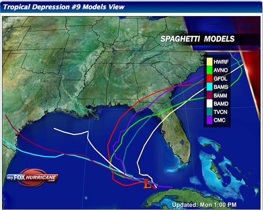
  • Most models show the system affecting areas of Florida towards the end of the week.

Still to Watch:
99L struggled most of last week to form as it encountered high wind shear and relatively dry air as it traveled west/northwest through the Caribbean. It passed through the Straits of FL this weekend and is now entering more favorable conditions for development, which has led to its formation into Tropical Depression 9. Winds have increased to 35 mph and are projected to continue to increase as convection around the low is forecast to increase as the week goes on. The storm is still moving W/NW as it moves through the Gulf, where it is projected to eventually stall and then begin moving N/NE toward the northeastern Gulf of Mexico around mid-week. Areas of the western coast of FL should maintain a watchful eye on the storm as the week progresses.

FMIT Member Preparedness Actions

  • FMIT Ride-Out teams are making plans to identify areas for initial deployment as necessary to assist Member with the response and recovery process. FMIT’s Property Insurance Policy affords many benefits to its members.
  • Members should continue to monitor the storm as well as FMIT Alerts and local/national weather forecasts.
  • Members throughout the western coast of FL should begin preparations for potential landfall later this week, which may include communications with internal emergency response leadership.
Share

You also might be interested in

Tropical Storm CindyTropical Storm Cindy Makes Landfall Early This Morning on Texas/Louisiana Border.

Jul 7, 2017

FMIT Alert Level 3 Moderate Tropical Storm Cindy Makes Landfall[...]

FMIT Alert Level 1: Hurricane Irma Weakens Slightly Over The Last 24 Hours With Maximum Sustained Winds Now at 110mph. 9-1-17

Sep 1, 2017

FMIT Alert Level 1 Low Hurricane Irma Weakens Slightly Over[...]

FMIT Alert: Sub-Tropical Storm Alberto Follow Up 5-29-18

May 29, 2018

FMIT MEMBER EMERGENCY CONTACT FORM REGISTER HERE FMIT MEMBER EMERGENCY CONTACT FORM[...]

Contact Information
  • SynergyNDS
  • 1400 Sarno Rd Melbourne, FL 32935
  • 888.580.7080

TrackDown℠ Mobile Application


Get it on Google Play


Download on the App Store
Links

Florida League of Cities
simpliCity
Florida Municipal Insurance Trust
Synergy ID

Click For More Information
simpliCity
Managed Vendor Program

© 2025 — SynergyNDS

  • Home
  • About Us
  • Our Services
  • Managed Programs
  • Projects
  • Testimonials
  • Videos
  • Contact Us
  • FMIT Alerts
Prev Next