• SynergyNDS
  • Home
  • About Us
  • Our Services
  • Managed Programs
  • Projects
    • Current Projects
    • Past Projects
    • Bids
  • Testimonials
  • Videos
  • Contact Us
  • FMIT Alerts

Call us today! 888.580.7080

Our Location
simpliCity Login
SynergyFMITSynergyFMIT
SynergyNDS is a leading Recovery Program
Manager for Public Entities with combined current
insured property in excess of $68 billion dollars.
synergynds, synergy recovery of florida, florida league of citiesSynergyNDS, Synergy Recovery of Florida, Florida League of CitiesSynergyNDS, Synergy Recovery of Florida, Florida League of CitiesSynergyNDS, Synergy Recovery of Florida, Florida League of CitiesSynergy Recovery of Florida, SynergyNDS, Florida League of Cities
  • SynergyNDS
  • Home
  • About Us
  • Our Services
  • Managed Programs
  • Projects
    • Current Projects
    • Past Projects
    • Bids
  • Testimonials
  • Videos
  • Contact Us
  • FMIT Alerts

Tropical Storm Warning: Tropical Storm Colin to make FL landfall 6-6-16

FMIT Alert Level 4:
Moderate-Moderate
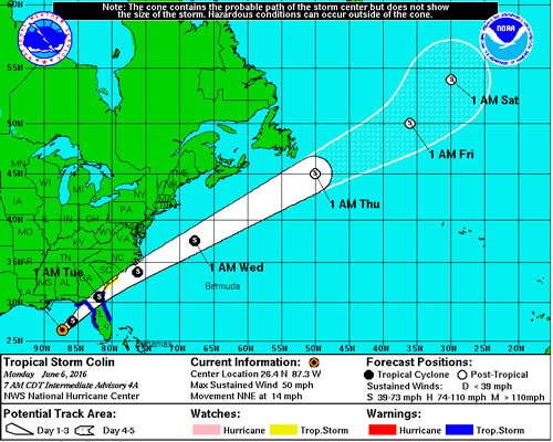
Tropical Storm Warning: Tropical Storm Colin to make landfall in Florida,
heavy rains Monday & Tuesday
9:00 am EST, Monday, June 6, 2016
Tropical Storm Colin has strengthened in the Gulf of Mexico and will bring the threat of heavy rain to parts of Florida and the Southeast Monday and Tuesday. Straight-line Winds, Microbursts and or isolated Tornado can be generated as the storms pass through.
FMIT has mobilized Ride-Out teams to potentially affected areas. Heavy rain and flooding is possible Monday through Wednesday across areas of the state. Call 855-FMIT-LOSS (855-364-8567, Option 3) to report any losses to your insured property and activate the Turnkey Recovery program.
Storm Imagery (Courtesy www.nhc.noaa.gov )

6-6-16-colin

Share

You also might be interested in

FMIT Alert Lvl 3: Florence Still Potential Rain Threat to North Florida 9-13-18

Sep 13, 2018

FMIT MEMBER EMERGENCY CONTACT FORM REGISTER HERE FMIT MEMBER EMERGENCY CONTACT FORM[...]

FMIT Alert Lvl 4: TS Nate Moving North Quickly Towards Gulf. Potential Landfall along Gulf Coast Sunday. Hurricane Watches Issued For FL Panhandle. 10-06-17

Oct 6, 2017

FMIT MEMBER EMERGENCY CONTACT FORM REGISTER HERE FMIT MEMBER EMERGENCY CONTACT FORM[...]

FMIT Alert Lvl 5 -Panhandle/Big Bend: Michael Quickly Approaching Panhandle Coast as a Powerful CAT 4 Hurricane With Winds of 140+ MPH 10-10-18

Oct 10, 2018

FMIT MEMBER EMERGENCY CONTACT FORM REGISTER HERE FMIT MEMBER EMERGENCY CONTACT FORM[...]

Contact Information
  • SynergyNDS
  • 1400 Sarno Rd Melbourne, FL 32935
  • 888.580.7080

TrackDown℠ Mobile Application


Get it on Google Play


Download on the App Store
Links

Florida League of Cities
simpliCity
Florida Municipal Insurance Trust
Synergy ID

Click For More Information
simpliCity
Managed Vendor Program

© 2025 — SynergyNDS

  • Home
  • About Us
  • Our Services
  • Managed Programs
  • Projects
  • Testimonials
  • Videos
  • Contact Us
  • FMIT Alerts
Prev Next