• SynergyNDS
  • Home
  • About Us
  • Our Services
  • Managed Programs
  • Projects
    • Current Projects
    • Past Projects
    • Bids
  • Testimonials
  • Videos
  • Contact Us
  • FMIT Alerts

Call us today! 888.580.7080

Our Location
simpliCity Login
SynergyFMITSynergyFMIT
SynergyNDS is a leading Recovery Program
Manager for Public Entities with combined current
insured property in excess of $68 billion dollars.
synergynds, synergy recovery of florida, florida league of citiesSynergyNDS, Synergy Recovery of Florida, Florida League of CitiesSynergyNDS, Synergy Recovery of Florida, Florida League of CitiesSynergyNDS, Synergy Recovery of Florida, Florida League of CitiesSynergy Recovery of Florida, SynergyNDS, Florida League of Cities
  • SynergyNDS
  • Home
  • About Us
  • Our Services
  • Managed Programs
  • Projects
    • Current Projects
    • Past Projects
    • Bids
  • Testimonials
  • Videos
  • Contact Us
  • FMIT Alerts

Tropics Update: Possible Storm in Gulf 6-3-16

FMIT Alert Level 2:
Low-Moderate
Tropics Update: Possibility of Tropical Depression or Tropical Storm Formation
in the Gulf of Mexico Next Week
1:00 pm EST, Friday, June 3, 2016
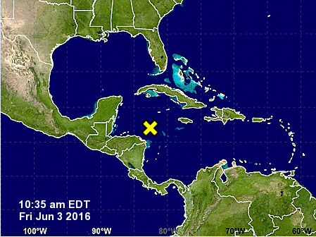
A band of showers and thunderstorms has formed over the western Caribbean Sea. This system is moving west-northwestward toward the Yucatan Peninsula of Mexico, and a low pressure area is expected to develop over the Yucatan or nearby waters later this weekend. This low has a chance to develop into a tropical cyclone as it subsequently moves across the eastern Gulf of Mexico and the Florida Peninsula beginning next week. Regardless of development, locally heavy rains and flooding are possible over areas of Florida during the next several days.
FMIT Turnkey Recovery is continuing to monitor NWS and Local Storm Reports and necessary preparation measures are being taken throughout the weekend as the storm approaches Florida. Heavy rain and flooding is possible Monday through Wednesday across areas of the state. Call 855-FMIT-LOSS (855-364-8567, Option 3) to report any losses to your insured property and activate the Turnkey Recovery program.
Storm Imagery (Courtesy www.nhc.noaa.gov  & www.weather.com)
tropics-update-2

tropics-update-1
Share

You also might be interested in

FMIT Alert Level 4: Hurricane Irma Currently A Category 5 Hurricane With Maximum Sustained Winds of 175mph. Models Coming into Agreement that Portions of Florida May Be Affected With Potential Impact This Weekend. Storm Path Will Determine the Area Affected and Intensity of Storm. 9-5-17

Sep 5, 2017

FMIT Alert Level 4 Moderate-High Hurricane Irma Currently A Category[...]

TD9 May Become a Tropical Storm Later Today. Heavy Rains Forecasted For Areas of The State, Particularly In The Big Bend Where the Storm is Projected to Make Landfall as Early as Thursday

Aug 30, 2016

FMIT Alert Level 2: Low-Moderate TD9 May Become a Tropical[...]

Irma Makes Landfall In Key West As Powerful CAT 4 Hurricane With Winds of 130mph. South Florida Coast At Risk of Major Storm Surge, Intense Winds and Flooding Rains as Irma Continues Its Path Up The Gulf Coast. 9-10-17

Sep 10, 2017

FMIT Alert Level 5 High Irma Makes Landfall In Key[...]

Contact Information
  • SynergyNDS
  • 1400 Sarno Rd Melbourne, FL 32935
  • 888.580.7080

TrackDown℠ Mobile Application


Get it on Google Play


Download on the App Store
Links

Florida League of Cities
simpliCity
Florida Municipal Insurance Trust
Synergy ID

Click For More Information
simpliCity
Managed Vendor Program

© 2026 — SynergyNDS

  • Home
  • About Us
  • Our Services
  • Managed Programs
  • Projects
  • Testimonials
  • Videos
  • Contact Us
  • FMIT Alerts
Prev Next