



• SynergyNDS
  • Home
  • About Us
  • Our Services
  • Managed Programs
  • Projects
    • Current Projects
    • Past Projects
    • Bids
  • Testimonials
  • Videos
  • Contact Us
  • FMIT Alerts

Call us today! 888.580.7080

Our Location
simpliCity Login
SynergyFMITSynergyFMIT
SynergyNDS is a leading Recovery Program
Manager for Public Entities with combined current
insured property in excess of $68 billion dollars.
synergynds, synergy recovery of florida, florida league of citiesSynergyNDS, Synergy Recovery of Florida, Florida League of CitiesSynergyNDS, Synergy Recovery of Florida, Florida League of CitiesSynergyNDS, Synergy Recovery of Florida, Florida League of CitiesSynergy Recovery of Florida, SynergyNDS, Florida League of Cities
  • SynergyNDS
  • Home
  • About Us
  • Our Services
  • Managed Programs
  • Projects
    • Current Projects
    • Past Projects
    • Bids
  • Testimonials
  • Videos
  • Contact Us
  • FMIT Alerts

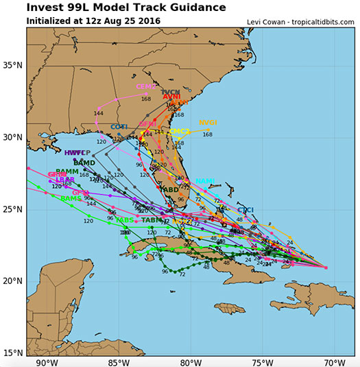
Tropical Disturbance 99L Still Struggling to Organize as it Moves Northwest Through The Carribean. Potential Still Exists For Interaction With Florida Later This Weekend 8-25-16

FMIT Alert Level 2:
Low-Moderate
Tropical Disturbance 99L Still Struggling to Organize as it Moves Northwest Through The Carribean.
Potential Still Exists For Interaction With Florida Later This Weekend.
9:00 am EST, Thursday, August 25, 2016

Latest from the National Hurricane Center:

“An area of low pressure associated with a tropical wave is centered just southeast of the Turks and Caicos Islands. The wave is producing gale-force winds over water to the north of Hispaniola, however, satellite images indicate that the shower and thunderstorm activity is well removed from the area of lowest pressure. Surface data also indicate that the low continues to lack a well-defined center.”

FMIT Ride-Out teams will remain on standby throughout the week into the weekend as the path and strength of the disturbance become more clear. Future alerts will be sent daily and then multiple times per day as it approaches Florida. Should the storm develop significantly, we will arrange pre-event webinars and calls to educate Members on FMIT’s mitigation and response procedures.
Storm Imagery (Courtesy www.nhc.noaa.gov/ and www.tropicaltidbits.com/ )
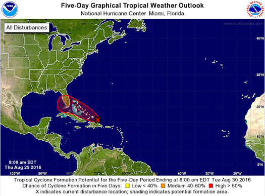
fmit-alert-spaghetti-8-25-16
Share

You also might be interested in

FMIT Alert – Dorian Now Out of FL Without Making Direct Landfall. Ride-Out Teams Currently Being Deployed to Assess Damages. 9-05-19

Sep 5, 2019

To Sign Up For FMIT Alerts CLICK HERE To Sign[...]

Trailing Feeder Bands From Hermine Continue to Bring Rain To Areas of Florida Along With Threat of Isolated Tornadoes Over the Next 12-24 Hrs. FMIT is Currently Contacting Members in Affected Areas And Ride Out Teams Remain Stationed To Provide Assistance With Damage Assessments Throughout Today

Sep 2, 2016

FMIT Alert: Post Hermine Response & Recovery Trailing Feeder Bands[...]

TD9 Shows Little Signs of Significant Growth or Increase in Organization Since This Morning as it Continues to Move West Into The Gulf of Mexico. Majority of Forecast Models Still Predicting Potential Landfall As Tropical Storm Later This Week in FL.

Aug 29, 2016

FMIT Alert Level 2: Low-Moderate TD9 Shows Little Signs of[...]

Contact Information
  • SynergyNDS
  • 1400 Sarno Rd Melbourne, FL 32935
  • 888.580.7080

TrackDown℠ Mobile Application


Get it on Google Play


Download on the App Store
Links

Florida League of Cities
simpliCity
Florida Municipal Insurance Trust
Synergy ID

Click For More Information
simpliCity
Managed Vendor Program

© 2026 — SynergyNDS

  • Home
  • About Us
  • Our Services
  • Managed Programs
  • Projects
  • Testimonials
  • Videos
  • Contact Us
  • FMIT Alerts
Prev Next