• SynergyNDS
  • Home
  • About Us
  • Our Services
  • Managed Programs
  • Projects
    • Current Projects
    • Past Projects
    • Bids
  • Testimonials
  • Videos
  • Contact Us
  • FMIT Alerts

Call us today! 888.580.7080

Our Location
simpliCity Login
SynergyFMITSynergyFMIT
SynergyNDS is a leading Recovery Program
Manager for Public Entities with combined current
insured property in excess of $68 billion dollars.
synergynds, synergy recovery of florida, florida league of citiesSynergyNDS, Synergy Recovery of Florida, Florida League of CitiesSynergyNDS, Synergy Recovery of Florida, Florida League of CitiesSynergyNDS, Synergy Recovery of Florida, Florida League of CitiesSynergy Recovery of Florida, SynergyNDS, Florida League of Cities
  • SynergyNDS
  • Home
  • About Us
  • Our Services
  • Managed Programs
  • Projects
    • Current Projects
    • Past Projects
    • Bids
  • Testimonials
  • Videos
  • Contact Us
  • FMIT Alerts

TD9 May Become a Tropical Storm Later Today. Heavy Rains Forecasted For Areas of The State, Particularly In The Big Bend Where the Storm is Projected to Make Landfall as Early as Thursday

FMIT Alert Level 2:
Low-Moderate
TD9 May Become a Tropical Storm Later Today. Heavy Rains Forecasted For Areas of The State, Particularly In The Big Bend Where the Storm is Projected to Make Landfall as Early as Thursday.
9:00am EST, Tuesday, August 30, 2016

Latest from the National Hurricane Center:

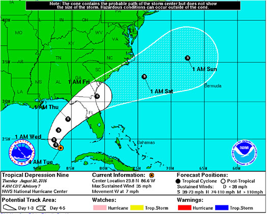
“The depression is moving toward the west near 7 mph (11 km/h). A slow west-northwestward motion is expected today. A turn toward the north-northwest is expected tonight, followed by a turn toward the north-northeast on Wednesday. On the forecast track, the center of the depression will continue to move slowly away from western Cuba, and move into the eastern Gulf of Mexico over the next 48 hours.”

FMIT Ride-Out teams will remain on standby throughout the the week as the path and strength of the tropical depression become more clear. Future alerts will be sent twice daily due to the storm’s projected path into FL later this week. Should the storm develop significantly, we will arrange pre-event webinars and calls to educate Members on FMIT’s mitigation and response procedures.
Storm Imagery (Courtesy www.nhc.noaa.gov/ and www.myfoxhurricane.com/ )

FMIT Discussion

  • Tropical Depression 9 is expected to strengthen into a Tropical Storm by later today.
  • Wind speeds remain at 35mph and are expected to grow to 65mph by later this week.
  • Heavy amounts of rainfall are still in the forecast for later this week with the possibility of flooding across parts of the state, including the Big Bend.
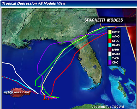
  • Most models show the system affecting areas of Florida towards the end of the week.
  • FMIT Alerts will now be sent only to Members in the projected path of the storm. Members in Central and Northern Counties will continue to receive alerts.

Still to Watch:
99L is projected to make a turn to the North/Northwest later today and then turn North/Northeast tomorrow. It is projected to increase in intensity slightly over the next couple of days. Winds remain at to 35 mph and are projected to continue to increase as convection around the low is forecast to increase as the week goes on. Areas of North Central, Big Bend, and the Panhandle should maintain a watchful eye on the storm as the week progresses.

FMIT Member Preparedness Actions

  • FMIT Ride-Out teams are making plans to identify areas for initial deployment as necessary to assist Member with the response and recovery process. FMIT’s Property Insurance Policy affords many benefits to its members.
  • Members should continue to monitor the storm as well as FMIT Alerts and local/national weather forecasts.
  • Members throughout the western coast of FL should begin preparations for potential landfall later this week, which may include communications with internal emergency response leadership.
Share

You also might be interested in

Matthew Has Strengthened to a CAT 4 Hurricane with Maximum Sustained Winds of 140mph.

Oct 6, 2016

FMIT Alert Level 5: High Matthew Has Strengthened to a[...]

FMIT Alert Level 2: Invest 90L Forms Over Southwestern Caribbean Sea; Current Conditions Favorable For Development Towards The End of This Week. 10-04-17

Oct 4, 2017

FMIT MEMBER EMERGENCY CONTACT FORM REGISTER HERE FMIT MEMBER EMERGENCY CONTACT FORM[...]

Trailing bands of Colin bring more wind and rainfall to FL into Tuesday 6-7-16

Jun 7, 2016

FMIT Alert Level 4: Moderate-High Trailing bands of Tropical Storm[...]

Contact Information
  • SynergyNDS
  • 1400 Sarno Rd Melbourne, FL 32935
  • 888.580.7080

TrackDown℠ Mobile Application


Get it on Google Play


Download on the App Store
Links

Florida League of Cities
simpliCity
Florida Municipal Insurance Trust
Synergy ID

Click For More Information
simpliCity
Managed Vendor Program

© 2025 — SynergyNDS

  • Home
  • About Us
  • Our Services
  • Managed Programs
  • Projects
  • Testimonials
  • Videos
  • Contact Us
  • FMIT Alerts
Prev Next