• SynergyNDS
  • Home
  • About Us
  • Our Services
  • Managed Programs
  • Projects
    • Current Projects
    • Past Projects
    • Bids
  • Testimonials
  • Videos
  • Contact Us
  • FMIT Alerts

Call us today! 888.580.7080

Our Location
simpliCity Login
SynergyFMITSynergyFMIT
SynergyNDS is a leading Recovery Program
Manager for Public Entities with combined current
insured property in excess of $68 billion dollars.
synergynds, synergy recovery of florida, florida league of citiesSynergyNDS, Synergy Recovery of Florida, Florida League of CitiesSynergyNDS, Synergy Recovery of Florida, Florida League of CitiesSynergyNDS, Synergy Recovery of Florida, Florida League of CitiesSynergy Recovery of Florida, SynergyNDS, Florida League of Cities
  • SynergyNDS
  • Home
  • About Us
  • Our Services
  • Managed Programs
  • Projects
    • Current Projects
    • Past Projects
    • Bids
  • Testimonials
  • Videos
  • Contact Us
  • FMIT Alerts

Severe Storm/Flood Alert 3-11-16

FMIT Alert Level 3:
Moderate
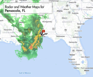
Severe Storm/Flood Alert: Heavy Rainfall is expected to impact areas of the Florida Panhandle this afternoon through the evening
3:28 pm CST, Friday, March 11, 2016
Heavy Rainfall is expected to impact areas of the Florida Panhandle this afternoon through the evening. A long line of strong cells are moving North/Northeast at 30mph. Winds between 30 and 40mph will be possible with these storms along with torrential rainfall. FMIT Ride-Out Teams in the area are reporting the heaviest rain moving through Pensacola right now.
National Weather Service in Mobile, AL has issued a Flood Advisory for Escambia and Santa Rosa Counties until 4:30 PM CST.
FMIT has mobilized Ride-Out teams to potentially affected areas. Call 855-FMIT-LOSS (855-364-8567, Option 3) to report any losses to your insured property and activate the Turnkey Recovery program.
Storm Imagery (Courtesy www.weather.com)
severe-weather-radar-map-pensacola
Share

You also might be interested in

Hermine Strengthens Into CAT 1 Hurricane With Winds Around Center Increasing to 75mph. Further Strengthening is Anticipated by the Time Landfall Occurs This Evening In/Around Big Bend/Eastern Panhandle. Disorganized Nature of Storm Still Has Wide Range of Path Guidance

Sep 2, 2016

FMIT Alert Level 5: High Hermine Strengthens Into CAT 1[...]

Matthew Strengthens Into CAT 1 Hurricane With Winds Around Center Increasing to 75mph As It Moves Into The Caribbean

Sep 29, 2016

FMIT Alert Level 1: Low Matthew Strengthens Into CAT 1[...]

FMIT Alert Level 3: Severe Storms Bring Heavy Amounts of Rain & Localized Flooding to Panhandle Counties; Flash Flood Watches Issued 8-30-17

Aug 30, 2017

FMIT Alert Level 3 Moderate Severe Storms Bring Heavy Amounts[...]

Contact Information
  • SynergyNDS
  • 1400 Sarno Rd Melbourne, FL 32935
  • 888.580.7080

TrackDown℠ Mobile Application


Get it on Google Play


Download on the App Store
Links

Florida League of Cities
simpliCity
Florida Municipal Insurance Trust
Synergy ID

Click For More Information
simpliCity
Managed Vendor Program

© 2025 — SynergyNDS

  • Home
  • About Us
  • Our Services
  • Managed Programs
  • Projects
  • Testimonials
  • Videos
  • Contact Us
  • FMIT Alerts
Prev Next