

Low-Moderate
Latest from the National Hurricane Center:
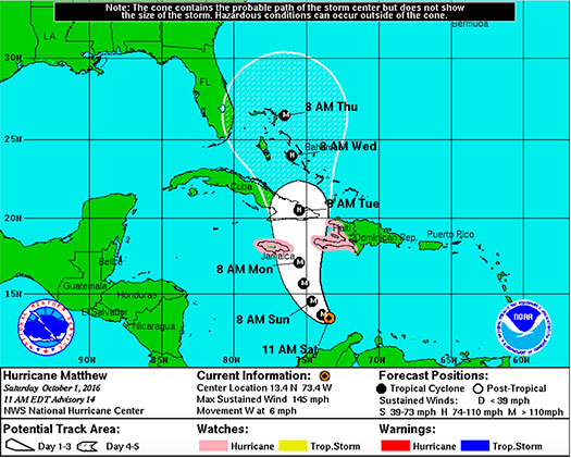
“At 1100 AM EDT (1500 UTC), the eye of Hurricane Matthew was located near latitude 13.4 North, longitude 73.4 West. Matthew is moving toward the west near 6 mph (9 km/h). A turn toward the west-northwest is forecast later today, followed by a turn toward the north-northwest on Sunday and toward the north on Monday. On the forecast track, the center of Matthew will move across the central Caribbean Sea today and Sunday, and approach Jamaica and southwestern Haiti Sunday night and Monday.”
FMIT continues to monitor Hurricane Matthew as it slowly begins to make a West-Northwest turn over the next 24-48 hours. Hurricane-force winds spread outward up to 45 miles (75km) from the middle and tropical-storm-force winds spread outward up to 205 miles (333 km). The approximated lowest central pressure based on figures from the aircraft is 947 mb (27.96 inches).
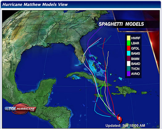
The Hurricane is forecasted to maintain It’s intensity over the coming days, however further strengthening is not expected and a decrease in intensity is likely once the storm makes landfall in Jamaica and Eastern Cuba. Currently, path models continue to mostly predict that it will narrowly pass Florida to the East sometime later next week. We will continue to send updates throughout the weekend as the Hurricane progresses.
FMIT Discussion
-
Matthew strengthened into a CAT 5 Hurricane late last night with winds up to 160mph but has weakened slightly this morning to a CAT 4 Hurricane with maximum sustained winds now at 145mph.
-
The eye of Matthew is beginning to become less distinguishable, which suggests that the storm may no longer be intensifying.
-
Matthew is expected to experience significant wind shear for the next 24 hours, causing some weakening. After that time, models suggest the shear should decrease, which should allow Matthew to still maintain its intensity.
-
Further weakening and disruption in the structure of Matthew is likely once the Hurricane makes landfall in Jamaica and Eastern Cuba.
-
West forward movement speed has decreased to 6mph with projections to begin turning West-Northwest later today.
-
Multiple factors including the distance the Hurricane travels West before turning North, how sharp the turn will be, movement speed and the strength of the Hurricane will ultimately determine Matthew’s future impact on Florida.
-
Most current path models continue to predict that it will narrowly pass Florida to the East sometime later next week.
-
We will continue to send updates throughout the weekend as the Hurricane progresses.
FMIT Member Preparedness Actions
-
Members should continue to monitor the storm as well as FMIT Alerts and local/national weather forecasts.
-
Members should also be in contact with their internal emergency management teams as the Hurricane progresses throughout the weekend should any procedures need to be implemented next week.