

FMIT Alert Level 2:
Low-Moderate
Low-Moderate
Matthew Strengthens Into CAT 2 Hurricane Overnight With Maximum Sustained Winds Increasing to 105mph And Further Strengthening Projected Over The Next 24-48 Hours. Potential Florida Impact Next Week Will Become More Clear After The Hurricane Makes It’s Northward Turn This Weekend.
10:00am EST, Friday, September 30, 2016
Latest from the National Hurricane Center:
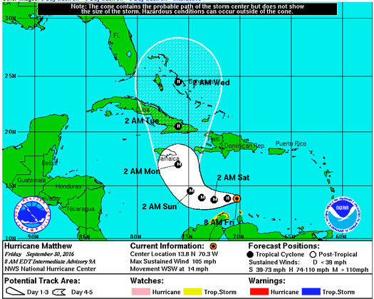
“At 800 AM AST (1200 UTC), the center of Hurricane Matthew was located by an Air Force Reserve Hurricane Hunter aircraft near latitude 13.8 North, longitude 70.3 West. Matthew is moving toward the west-southwest near 14 mph (22 km/h). A turn toward the west is expected later today, and this westward motion with a decrease in forward speed are forecast through Saturday. A turn toward the northwest is expected Saturday night or Sunday.”
Latest From FMIT:
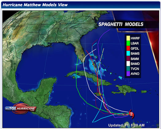
FMIT continues to monitor Hurricane Matthew. Forecast models generally predict that it will continue to head West for the next 24-48 hours and then begin to turn towards the North this weekend. The further Matthew travels West before turning North, the greater the possibility will be that it will impact Florida. Currently, path models mostly predict that it will narrowly pass Florida to the East sometime later next week. We will continue to send updates throughout the weekend as the Hurricane progresses.
Storm Imagery (Courtesy www.nhc.noaa.gov/ and www.myfoxhurricane.com/ )
Additional information and imagery can be found on your simpliCity℠ Dashboard.
FMIT Discussion
-
Matthew strengthened into a CAT 2 Hurricane overnight with winds now up to 105mph and will continue to strengthen, possibly into a CAT 3 Hurricane within the next 24-48 hours.
-
West forward movement speed at 14mph with projections to begin turning North over the weekend.
-
Multiple factors including the distance the Hurricane travels West before turning North, how sharp the turn will be, movement speed and the strength of the Hurricane will ultimately determine Matthew’s future impact on Florida.
-
Maximum sustained winds are expected to exceed 110mph after Matthew turns North, forming a CAT 3 Hurricane, however it is projected to weaken after it makes landfall in Cuba.
-
Most current path models predict that it will narrowly pass Florida to the East sometime later next week.
-
We will continue to send updates throughout the weekend as the Hurricane progresses.
FMIT Member Preparedness Actions
-
Members should continue to monitor the storm as well as FMIT Alerts and local/national weather forecasts.
-
Members should also be in contact with their internal emergency management teams as the Hurricane progresses throughout the weekend should any procedures need to be implemented next week.