

FMIT Alert:
Post Hermine Response & Recovery
Post Hermine Response & Recovery
Hermine Makes Landfall in Florida Overnight as CAT 1 Hurricane Causing Significant Damage In/Around Big Bend/Eastern Panhandle. Members Affected By Hermine Should Contact FMIT Turnkey Recovery Team to Assist With Post-Storm Damage Assessments. Storm Surge, Rain From Hurricane Feeder Bands Expected Along With Threat of Isolated Tornadoes Over the Next 12-24 Hrs.
10:30am EST, Friday, September 2, 2016
Latest from the National Hurricane Center:
“Hermine is moving toward the north-northeast near 14 mph (22 km/h) and this motion is expected to continue today and Saturday. On the forecast track, the center of Hermine will continue to move across southeastern Georgia today, move across the coastal Carolinas tonight and move offshore of the North Carolina coast on Saturday.”
Latest From FMIT:
FMIT Ride-Out teams and CIRT Vendors are currently stationed in affected areas to support response and recovery efforts. FMIT is implementing its Property Claims CAT Team procedures in Orlando. Call 844-FMIT-CAT (844-364-8228) to Request Assistance with Damage Reporting and to Report Damages.
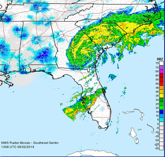
Storm Imagery (Courtesy National Weather Service )
Additional information and imagery can be found on your simpliCity℠ Dashboard.
FMIT Discussion
-
Contact 844-FMIT-CAT (844-364-8228) to be connected directly to our FMIT Property CAT Team for assistance with Reporting Damages and to Report Damages.
-
Hermine made landfall in FL overnight and has now decreased to a Tropical Storm as it makes its way into Georgia.
-
Some Storm Surge, Rain from Feeder Bands Still Expected Along with Threat of Isolated Tornadoes Over the Next 12-24 Hrs.
-
The FMIT Claims Team in Orlando is currently starting rapid damage assessments by the Adjusting Team.
-
FMIT/Synergy making phone calls to Members throughout the day to gather data on any damages sustained resulting from the storm.
Still to Watch:
Members should still be aware of storm surge, rain from feeder Bands, & threat of isolated tornadoes in the wake of Hermine over the Next 12-24 Hrs.
FMIT Member Preparedness Actions
-
Ride Out teams have been stationed in the Big Bend, Panhandle and Tallahassee areas to assist Members with the response and recovery process.
-
FMIT’s Property Insurance Policy affords many benefits to its members.
-
Members should continue to monitor the storm as well as FMIT Alerts and local/national weather forecasts.
-
Members throughout the western coast of FL should be implementing response and recovery procedures, which may include communications with internal emergency response leadership.
-
If utilizing the FMIT Turnkey Recovery program, please review any contracts you currently have with companies that provide emergency response products & services and contact them to notify them that they will be required to perform work under the coordination of the FMIT Turnkey Recovery program to ensure all losses and associated costs are properly managed and submitted through your insurer and FEMA for proper potential reimbursement.
-
Review Critical Assets that would be most susceptible to damage from an impending hurricane while being critical to municipal operations. Be prepared to share this list and potential mitigation procedures with Synergy/FMIT in advance of the storm. Critical Assets generally include Water Treatment Plant Assets, Critical Community Facilities, etc…
-
Ensure that any coastal assets close to the ocean (lifeguard stands, park equipment, etc…) have been moved away from potential storm surge levels.