High
(Central East Coast & North East Coast Counties Only)
Latest from the National Hurricane Center:
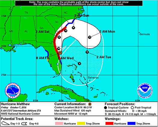
“At 800 AM EDT (1200 UTC), the eye of Hurricane Matthew was located near latitude 28.9 North, longitude 80.3 West. Matthew is moving toward the north-northwest near 13 mph (20 km/h), and this general motion is expected to continue today. A turn toward the north is expected tonight or Saturday. On the forecast track, the center of Matthew will be moving near or over the east coast of the Florida peninsula through tonight, and near or over the coasts of Georgia and South Carolina on Saturday.”
For the next 24-36 hours, Matthew is expected to slowly move Northward and then Northeastward as it affects North Florida and eventually Georgia and South Carolina over the weekend. After that time, a weakening Matthew is expected to turn slowly Southeastward and then Southward back down into the Atlantic with some potential to interact with FL later next week. We will keep Members in proximity of the storms path updated on the status if models predict potential for interaction with FL.
Hurricane-force winds spread outward up to 60 miles (95km) from the center and tropical-storm-force winds spread outward up to 185 miles (295 km). The approximated lowest central pressure based on figures from the aircraft is 938 mb (27.70 inches).
FMIT Member Preparedness Actions
-
If utilizing the FMIT Turnkey Recovery program, please review any contracts you currently have with companies that provide emergency response products & services and contact them to notify them that they will be required to perform work under the coordination of the FMIT Turnkey Recovery program to ensure all losses and associated costs are properly managed and submitted through your insurer and FEMA for proper potential reimbursement.
-
Review Critical Assets that would be most susceptible to damage from an impending hurricane while being critical to municipal operations. Be prepared to share this list and potential mitigation procedures with Synergy/FMIT in advance of the storm. Critical Assets generally include Water Treatment Plant Assets, Critical Community Facilities, etc…
-
Members should make sure that they have downloaded their most recent Insurance Policy from FMIT and from other Insurers.
-
Make sure that all Damage Assessment Team Members have downloaded “TrackDown – Government Edition” from the Google Play Store or the Apple iTunes Store and have logged in prior to the storm using your organization’s Username and Password.
-
Members should familiarize themselves on the steps for performing Damage Assessments using TrackDown by Clicking Here.
-
TrackDown user information is being emailed to Members and will continue into tomorrow.
-
If you have not yet received your TrackDown username and password, please email trackdown@synergyid.com to request it.
-
Members should continue to monitor the storm as well as FMIT Alerts and local/national weather forecasts.
-
Members should refer to materials from this week’s webinars available on the FMIT Alert web page by Clicking Here.
FMIT Discussion
-
Matthew weakens to a CAT 3 Hurricane overnight with maximum sustained winds now at 120mph. The eye of Matthew remains just off of land as the Hurricane continues to make its way up the Eastern coast of Florida.
-
FEMA Declaration for Matthew – action authorizes the Department of Homeland Security, Federal Emergency Management Agency (FEMA), to coordinate all disaster relief efforts.
-
The action will help the counties of Baker, Brevard, Broward, Citrus, Clay, Duval, Flagler, Glades, Hendry, Hernando, Highlands, Indian River, Lake, Marion, Martin, Miami-Dade, Monroe, Nassau, Okeechobee, Orange, Osceola, Palm Beach, Polk, Putnam, Seminole, St. Johns, St. Lucie, and Volusia.
-
Specifically, FEMA is authorized to identify, mobilize, and provide at its discretion, equipment and resources necessary to alleviate the impacts of the emergency. Emergency protective measures, limited to direct federal assistance, will be provided at 75 percent federal funding.
-
For the next 48 hours, Matthew is expected to move Northward and then Northeastward. After that time, a weakening Matthew is expected to turn slowly Southeastward and then Southward.
-
We will continue to send updates throughout the coming days as the Hurricane continues to progress up the Eastern coast of Florida.