• SynergyNDS
  • Home
  • About Us
  • Our Services
  • Managed Programs
  • Projects
    • Current Projects
    • Past Projects
    • Bids
  • Testimonials
  • Videos
  • Contact Us
  • FMIT Alerts

Call us today! 888.580.7080

Our Location
simpliCity Login
SynergyFMITSynergyFMIT
SynergyNDS is a leading Recovery Program
Manager for Public Entities with combined current
insured property in excess of $68 billion dollars.
synergynds, synergy recovery of florida, florida league of citiesSynergyNDS, Synergy Recovery of Florida, Florida League of CitiesSynergyNDS, Synergy Recovery of Florida, Florida League of CitiesSynergyNDS, Synergy Recovery of Florida, Florida League of CitiesSynergy Recovery of Florida, SynergyNDS, Florida League of Cities
  • SynergyNDS
  • Home
  • About Us
  • Our Services
  • Managed Programs
  • Projects
    • Current Projects
    • Past Projects
    • Bids
  • Testimonials
  • Videos
  • Contact Us
  • FMIT Alerts

Matthew Remains a Powerful CAT 4 Hurricane With Maximum Sustained Winds of 130mph

FMIT Alert Level 2:
Low-Moderate
Matthew Remains a Powerful CAT 4 Hurricane With Maximum Sustained Winds of 130mph. Forecast Models Continue To Show Matthew Maintaining Its Intensity Over The Coming Days With Little To No Strengthening Expected. Matthew Has Begun Turning North At 6mph And Is Expected To Stay On A Northern Path. Still Some Potential to Impact Florida Next Week. Center of Hurricane Matthew Projected To Pass Approximately 150-300 miles To The East of Florida Thursday And Friday This Week.
10:00am EST, Monday, October 3, 2016

Latest from the National Hurricane Center:

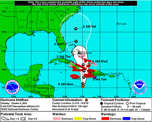
“At 800 AM EDT (1200 UTC), the eye of Hurricane Matthew was located near latitude 15.4 North, longitude 74.9 West. Matthew is moving toward the north near 6 mph (9 km/h). A general northward motion with some increase in forward speed is expected through Tuesday. On the forecast track, the center of Matthew will approach Jamaica and southwestern Haiti tonight, and eastern Cuba on Tuesday.”

Latest From FMIT:

FMIT continues to monitor Hurricane Matthew as it begins heading North. Hurricane-force winds spread outward up to 30 miles (45km) from the middle and tropical-storm-force winds spread outward up to 195 miles (315 km). The approximated lowest central pressure based on figures from the aircraft is 943 mb (27.85 inches).

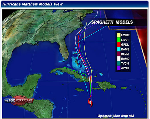
The overall organization of Matthew has changed little overnight but is forecasted to maintain Its intensity as it continues to move North. Further strengthening is not expected and a decrease in intensity is likely once the storm makes landfall in Jamaica and Eastern Cuba. Currently, path models continue to mostly predict that it will narrowly pass Florida to the East sometime later next week. We will continue to send updates throughout the week as the Hurricane progresses.

Storm Imagery (Courtesy www.nhc.noaa.gov/ and www.myfoxhurricane.com/ )
Additional information and imagery can be found on your simpliCity℠ Dashboard.

FMIT Discussion

  • Matthew remains a powerful CAT 4 Hurricane with maximum sustained winds of 130mph and is expected to maintain intensity.
  • Matthew is forecast to continue in low shear and over warm water while it progresses northward toward the Greater Antilles. Further strengthening is possible, but variations in intensity are likely due to eyewall cycles that are difficult to predict.
  • Further weakening and disruption in the structure of Matthew is likely once the Hurricane makes landfall in Jamaica and Eastern Cuba.
  • North forward movement has begun overnight with speed increasing to 6mph with projections to continue North later today into tonight.
  • Still some potential to impact Florida next week. Center of Hurricane Matthew Projected To Pass Approximately 150-300 miles To The East of Florida Thursday And Friday This Week.
  • We will continue to send updates throughout the week as the Hurricane progresses.
Share

You also might be interested in

Matthew Strengthens Into CAT 2 Hurricane Overnight With Maximum Sustained Winds Increasing to 105mph And Further Strengthening Projected Over The Next 24-48 Hours

Sep 30, 2016

FMIT Alert Level 2: Low-Moderate Matthew Strengthens Into CAT 2[...]

FMIT Alert Lvl 1 – Tropical Storm Dorian Forms East of The Lesser Antilles. Possible Strengthening Into Hurricane And Interaction With FL Next Week 8-25-19

Aug 26, 2019

To Sign Up For FMIT Alerts CLICK HERE To Sign[...]

Hurricane Irma Follow Up: FMIT Information for Reporting 1st Party Property Storm Damages 9-12-17

Sep 15, 2017

Hurricane Irma Follow Up: FMIT Information for Reporting 1st Party[...]

Contact Information
  • SynergyNDS
  • 1400 Sarno Rd Melbourne, FL 32935
  • 888.580.7080

TrackDown℠ Mobile Application


Get it on Google Play


Download on the App Store
Links

Florida League of Cities
simpliCity
Florida Municipal Insurance Trust
Synergy ID

Click For More Information
simpliCity
Managed Vendor Program

© 2025 — SynergyNDS

  • Home
  • About Us
  • Our Services
  • Managed Programs
  • Projects
  • Testimonials
  • Videos
  • Contact Us
  • FMIT Alerts
Prev Next