• SynergyNDS
  • Home
  • About Us
  • Our Services
  • Managed Programs
  • Projects
    • Current Projects
    • Past Projects
    • Bids
  • Testimonials
  • Videos
  • Contact Us
  • FMIT Alerts

Call us today! 888.580.7080

Our Location
simpliCity Login
SynergyFMITSynergyFMIT
SynergyNDS is a leading Recovery Program
Manager for Public Entities with combined current
insured property in excess of $68 billion dollars.
synergynds, synergy recovery of florida, florida league of citiesSynergyNDS, Synergy Recovery of Florida, Florida League of CitiesSynergyNDS, Synergy Recovery of Florida, Florida League of CitiesSynergyNDS, Synergy Recovery of Florida, Florida League of CitiesSynergy Recovery of Florida, SynergyNDS, Florida League of Cities
  • SynergyNDS
  • Home
  • About Us
  • Our Services
  • Managed Programs
  • Projects
    • Current Projects
    • Past Projects
    • Bids
  • Testimonials
  • Videos
  • Contact Us
  • FMIT Alerts

Tropical Disturbance 99L Weakens Overnight Due to Strong Upper Level Wind Shear. Potential Still Exists For Interaction With South Florida This Weekend, Primarily In The Form of Heavy Rains 8-26-16

FMIT Alert Level 1:
Low
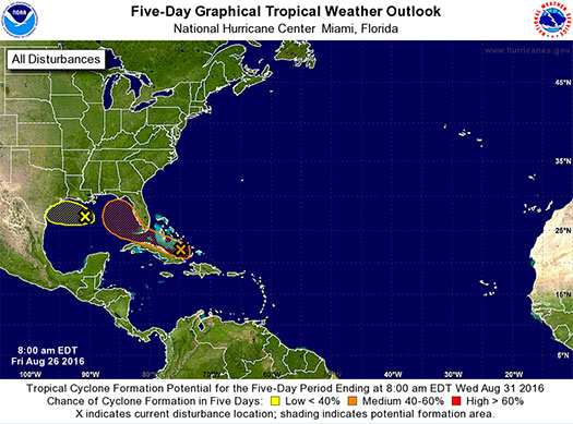
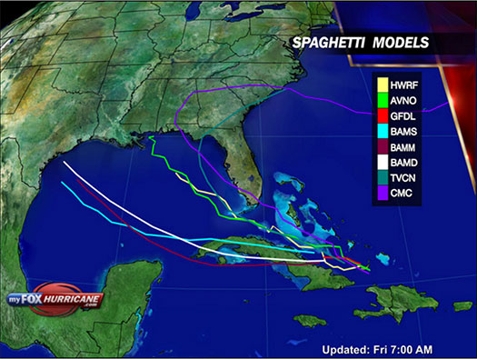
Tropical Disturbance 99L Weakens Slightly as it Moves Northwest Through The Caribbean.
Potential Still Exists For Interaction With Florida Later This Weekend.
9:00 am EST, Friday, August 26, 2016

Latest from the National Hurricane Center:

“A weak area of low pressure extending from eastern Cuba northward to the central Bahamas is producing disorganized shower and thunderstorm activity. Upper-level winds are expected to remain unfavorable for significant development during the next couple of days while the system moves west-northwestward at about 10 mph.”

FMIT Ride-Out teams will remain on standby through the end of the week into the weekend as the path and strength of the disturbance become more clear. Future alerts will be sent daily unless the storm strengthens as it approaches Florida. Should the storm develop significantly, we will arrange pre-event webinars and calls to educate Members on FMIT’s mitigation and response procedures.
Storm Imagery (Courtesy www.nhc.noaa.gov/ and www.myfoxhurricane.com/ )
Share

You also might be interested in

Hurricane Irma Currently A Category 5 Hurricane With Maximum Sustained Winds of 185mph. Gov. Rick Scott Declares State of Emergency For Florida. Mandatory Evacuations Issued to Begin For Monroe County Tomorrow Morning. 9-5-17

Sep 6, 2017

FMIT Alert Level 4 Moderate-High Hurricane Irma Currently A Category[...]

TD9 May Become a Tropical Storm Later Today. Heavy Rains Forecasted For Areas of The State, Particularly In The Big Bend Where the Storm is Projected to Make Landfall as Early as Thursday

Aug 30, 2016

FMIT Alert Level 2: Low-Moderate TD9 May Become a Tropical[...]

FMIT Alert Level 4: Sub-Tropical Storm Alberto Moving N, Isolated Flooding/Tornadoes Primary Threats 5-27-18

May 27, 2018

FMIT MEMBER EMERGENCY CONTACT FORM REGISTER HERE FMIT MEMBER EMERGENCY CONTACT FORM[...]

Contact Information
  • SynergyNDS
  • 1400 Sarno Rd Melbourne, FL 32935
  • 888.580.7080

TrackDown℠ Mobile Application


Get it on Google Play


Download on the App Store
Links

Florida League of Cities
simpliCity
Florida Municipal Insurance Trust
Synergy ID

Click For More Information
simpliCity
Managed Vendor Program

© 2025 — SynergyNDS

  • Home
  • About Us
  • Our Services
  • Managed Programs
  • Projects
  • Testimonials
  • Videos
  • Contact Us
  • FMIT Alerts
Prev Next